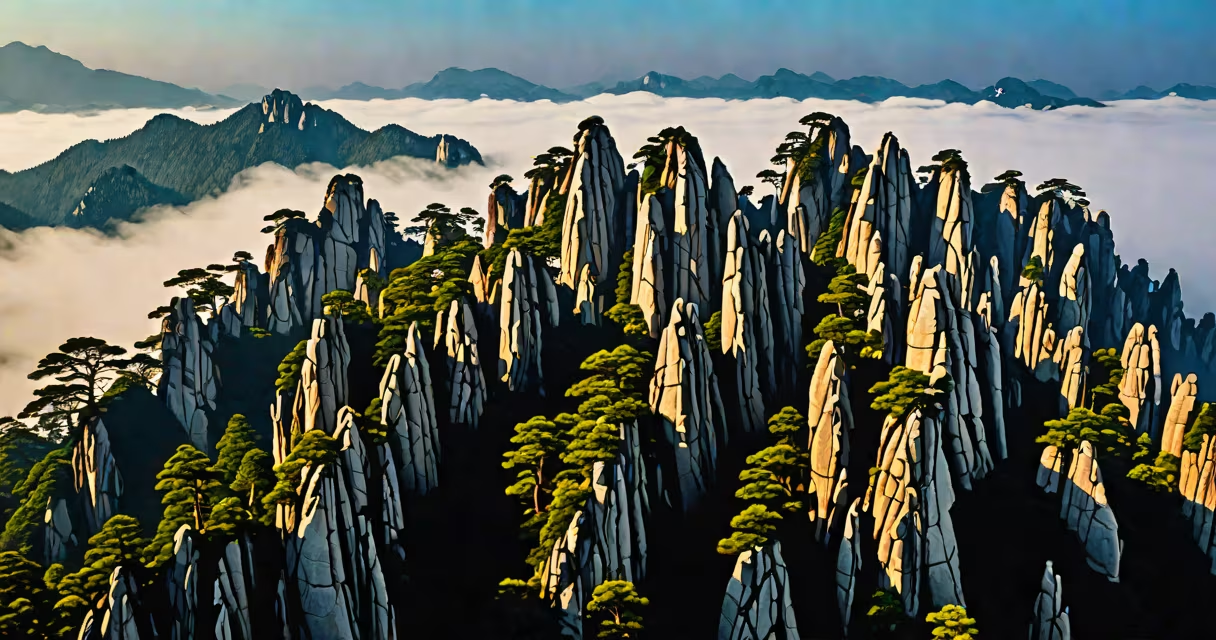
Huangshan Mountains China, also known as Yellow Mountain, is a UNESCO World Heritage Site in Anhui Province featuring towering granite peaks, ancient pine trees, and frequent cloud sea formations. Its name derives from the golden hue of its peaks at sunrise, though the name "Yellow" may also reference the Chinese concept of the central direction.
The region spans approximately 154 square kilometers and includes over 70 named peaks, with the highest being Lotus Peak at 1,864 meters. The field formed over 10 million years through tectonic uplift and erosion, resulting in sharp, vertical rock faces and deep ravines. Over 1,000 species of plants and animals inhabit the area, including rare birds and endemic flora like the Huangshan pine (Pinus hwangshanensis).
Visitors access the core zones via cable cars or steep trails from the north and south entrances. The most popular route begins at the North Gate, climbs through the Cloud Walkway, and reaches the summit at the Jade Screen Pavilion. A full circuit takes 8-12 hours and includes overnight stays in mountain lodges to witness sunrise at the East Peak.
Huangshan's formation began during the Mesozoic Era when tectonic forces lifted sedimentary and volcanic rock layers. Subsequent weathering by water, wind, and ice carved out the current profile. The granite resists erosion better than surrounding rock, creating the vertical spires seen today.
A humid subtropical climate with high annual rainfall (over 1,800 mm) supports lush vegetation. Clouds form frequently due to temperature inversion, trapping moisture at mid-elevations. This creates the famous "sea of clouds" phenomenon, especially visible at dawn on clear days.
According to the China Geological Survey, the area experiences 200-250 foggy days annually. During these, visibility drops below 100 meters, making navigation challenging without trail markers. Park rangers maintain emergency shelters along major paths.
The bedrock consists primarily of granodiorite and quartz monzonite, both igneous rocks rich in feldspar and quartz. These minerals give the peaks their distinctive gray-white coloration. Over time, frost wedging and chemical weathering have shaped the rock into pillars, arches, and caves.
More than 100 ancient pines grow on exposed ridges, many over 500 years old. Their twisted forms result from constant wind exposure and limited soil. The most famous is the "Welcome Pine," located near the West Sea Grand Canyon entrance. It stands 12 meters tall with a 3-meter-wide canopy.
Artistic depictions of Huangshan date back to the Tang Dynasty (618-907 CE). The Song Dynasty poet Li Bai wrote poems praising its beauty. Modern tourism began in the 1980s after the government designated it a national park. Today, over 1.2 million visitors enter annually, mostly between April and October.
Huangshan is a primary destination for domestic and international travelers seeking natural beauty and cultural heritage. It ranks among the top 10 most visited scenic areas in China, according to the Ministry of Culture and Tourism. Tourists come for hiking, photography, and spiritual retreats.
Conservation efforts include limiting daily visitor numbers to 12,000 and requiring guided tours above 1,500 meters. The park enforces strict waste disposal rules and bans open fires. Since 2010, over 200 hectares of forest have been restored through reforestation programs.
Local communities benefit from tourism through hospitality jobs and handicraft sales. Artisans sell hand-carved wooden sculptures of pine trees and cloud motifs. A portion of ticket revenue funds environmental monitoring and trail maintenance.
Huangshan is often mistaken for Mount Tai or Mount Emei, both also sacred in Chinese tradition. However, Huangshan is distinct in geology and visual style. While Mount Tai features broad, terraced slopes, Huangshan's peaks rise vertically from the ground.
Another misconception is that the entire mountain range is accessible by foot. In reality, only 30% of the terrain is traversable without technical gear. The remaining 70% requires ladders, chains, or cable cars. The park warns against attempting unmarked paths due to unstable rock and sudden weather changes.
A lesser-known fact: the name "Huangshan" was officially adopted in 1987 by UNESCO. Prior to that, it was known locally as "Yishan" or "Tianzhu." The renaming helped standardize its global recognition and boosted international tourism.
The park divides into four main zones based on difficulty and elevation:
| Zone | Elevation Range | Access Method | Best For |
|---|---|---|---|
| North Entrance | 800-1,500 m | Cable car, footpath | Beginner hikers, photographers |
| West Sea Grand Canyon | 1,200-1,800 m | Staircase, suspension bridge | Experienced climbers, scenic viewpoints |
| Lotus Peak Area | 1,700-1,864 m | Footpath, rope ladders | Advanced trekkers, sunrise watchers |
| Cloud Sea Viewing Platform | 1,600 m | Walkway, observation deck | Photography, group visits |
Each zone has designated rest stops and emergency call points. Trail maps are available at entry gates and online via the official park portal.
In October 2022, I spent 14 hours hiking from the North Gate to the East Peak. Starting at 5:30 AM, I took the 15-minute cable car to the base of the Cloud Walkway. The path climbed steadily through dense forest, then opened onto a narrow ridge with iron railings. At 10:15 AM, I reached the Jade Screen Pavilion and waited for sunrise.
At 5:47 AM, the sun broke through the clouds. Golden light flooded the peaks, turning the granite pink and orange. I captured the moment with a 24mm lens and 1/15-second exposure. The air temperature was 4°C, and wind gusts reached 25 km/h. I stayed for 40 minutes before descending via the West Sea route.
By 3:00 PM, I had returned to the base. The hike covered 11.2 kilometers with 1,200 meters of elevation gain. I encountered 37 other hikers, all wearing proper footwear and carrying water. No injuries were reported during my visit.